The Missoula City Council Monday approved a new zoning code, map and development requirements, all aimed at increasing housing throughout the city.
The code implements the city’s new land use plan, which emphasizes expanding housing opportunities, improving walkability and addressing climate goals. The new rules encourage a wider range of housing types across Missoula’s neighborhoods, marking a significant change for some areas that have been largely insulated from development in recent years.
“I just hope the community supports this and does not balk at change,” Council Member Gwen Jones said during the meeting. “If we can embrace this change, it will work to keep Missoula vibrant, inclusive, community-oriented, and maybe it’s a place where our grandkids can live.”
The council approved the unified development code at the end of a five-and-a-half-hour meeting, following public comment and consideration of four amendments.
The unified development code encompasses zoning, subdivision, public works and parks-related regulations that were previously separated in different documents and sometimes conflicted with each other, according to the city. The updated Standards and Specifications Manual includes administrative rules, design standards and details, and clarifies how projects can meet code requirements.
Since mid-November, the planning commission and city council have spent about 75 hours in public meetings reviewing the code, said Council Member Mike Nugent. The council, over the last three weeks, debated more than 50 amendments to the code and zoning map approved by the planning commission in December and proposed by staff and council members.
“There’s no such thing as a perfect public process,” Nugent said. “Amendments come from elected officials at the end, that’s just the way things go, but it certainly doesn’t dismiss anything that led to that point in the conversation.”
The code reform began more than three years ago, when the city began collecting public feedback on its new land-use plan. The city’s review of the code found barriers to housing equity, supply, diversity, affordability and infill development, and that it did not support transportation and climate policies and was difficult to navigate.
The plan and the code include feedback from residents as well as developers, architects and other frequent users of the code.
The code update followed the December 2024 adoption of the Our Missoula 2045 Land Use Plan, which will guide the city’s growth and development over the next 20 years. The plan emphasized expanding housing opportunities to accommodate the projected population growth of the city and some surrounding county land, which is expected to reach 37,000 people by 2045. The plan called for 1,100 to 1,500 new housing units annually for the next 10 years to address the current deficit and meet new demand.
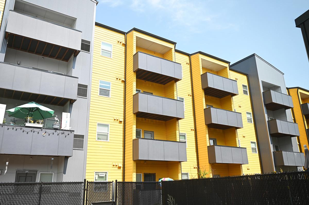
The new zoning map would allow apartments in 89% of residential and mixed-use districts, with only rural districts restricted to single-family homes or duplexes, city staff said previously. That’s a significant change from the current zoning, which allows only single-family homes or duplexes in 64% of the city’s residential areas.
RELATED

Missoula City Council adopts 20-year growth plan
The Missoula City Council has adopted the document that will guide the next 20 years of the city’s growth and development and lays the groundwork for increased housing density citywide.
The new land use plan and code also incorporates requirements from the 2023 Montana Land Use and Planning Act, including allowing at least two units per parcel in all residential areas. It also outlines changes to public participation and moves more development projects, like subdivisions, to administrative review.
The new code has 22 zoning districts, including seven residential, seven mixed-use, and eight special-use districts. The former code included 38 zoning districts, 21 overlays and 95 planned-unit development districts. The new code removes all overlays except the airport hazard area and four historic district overlays, including at Fort Missoula.
The residential districts are categorized into rural, limited-urban and urban, with more housing units permitted in the limited-urban and urban districts. The rural district is the only residential area that doesn’t allow at least a triplex.
The code regulates building size through a calculation based on parcel size. The council in January removed the unit cap for apartment buildings in urban residential districts and adjusted the calculation to allow for larger buildings in those districts.
All residential areas allow small-scale neighborhood commercial development, like a corner store or coffee shop. These businesses are allowed in new and existing buildings on corners and mid-block.
RELATED
Resident-driven zoning reform in Missoula
While builder and ProHousing Missoula member Chris Chitty is used to “slogging it out in the trenches of zoning,” most people don’t think about the rules that help make neighborhoods what they are, he said. ProHousing is trying to change that as the city undergoes a major update to its growth policy and development regulations.
Mixed-use districts include limited-urban, urban and downtown, where all building types are allowed with no density restrictions.
Special-use districts are transitional, industrial, open space and civic, and allow for a variety of uses. The transitional district was created to provide flexibility to encourage residential, commercial and low-intensity industrial development in areas with industrial lots and block patterns transitioning to mixed-use, according to the code. A handful of areas will have this zoning, including parts of the River Road neighborhood near Russell Street, east of Ryman between the railroad tracks and Interstate 90, and some areas around West Broadway north of Mullan Road.
The council in January removed parking requirements for commercial and industrial districts. The new state law already limited parking requirements for certain housing, leading the city to eliminate parking minimums for all residential uses.
Council Member Bob Campbell, who proposed the change, said Monday that landowners and developers know what’s best for their business and should be left to decide how much parking they need.
The council last month also approved several amendments that adjust requirements for lot sizes, setbacks, entrances, building widths, building transparency, signs, landscaping, activity areas and infrastructure.
The council also approved a handful of zoning map amendments to “smooth” areas where the same block had multiple zoning districts or to better match surrounding zoning.
RELATED
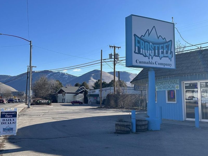
Missoula looks to add restrictions on location of marijuana dispensaries
Missoula’s proposed zoning code is set to include new restrictions on where marijuana dispensaries can be located, following concerns about increased youth drug use and the high density of dispensaries in the city.
After a lengthy discussion Monday, the council changed the zoning for a proposed subdivision in East Missoula, somewhat undoing the downzoning it approved for the property last Wednesday. The changes follow comments from East Missoula residents concerned that the area lacks infrastructure to support the Aspire Subdivision and higher-density development.
In August 2024, the council annexed the 35-acre property, rezoned it to include a neighborhood character overlay and approved the preliminary plan for the 250-unit subdivision, located adjacent to the Clark Fork River and Interstate 90. The project has been on hold as a lawsuit over the city’s approval plays out.
The council Jan. 28, approved Council Member Sean McCoy’s proposal to change the zoning district for the property to a lower density residential district. In a split vote Monday, the council approved a staff proposal to revert to a higher density district because the zone would not have allowed the developer to build the subdivision as planned. Brian Throckmorton, with 406 Engineering, said the developer wants to build what the council previously approved and doesn’t plan to add more units.
Many public comments Monday focused on East Missoula and sign regulations that concerned billboard owners. A handful of residents encouraged the city council to approve the new zoning code.
“This zoning code represents a big step from point A to point B,” said Colin Lane with MMW Architects. “Point B, I think our community is largely in alignment on what that looks like. It’s more walkable, it has parks, it has trees, it has housing, housing that people can actually afford, and it has some density, some urbanness to it in the core. … We may not always agree on how to get from point A to point B, but we do agree generally on what point B looks like.”
The council unanimously approved the zoning code and amendments to the land use plan. The code will go into effect in 30 days, but development review applications submitted within 120 days of the effective date can choose whether to be reviewed under the new or old code.
The mayor and council members applauded the city staff’s work on the effort and said they look forward to addressing any necessary changes, including the sign regulations flagged by business owners, and other specific issues as part of the next phase of code reform.
“Missoula is choosing to meet the urgency of housing affordability and attainability with this follow-through with the unified development code, and we did it with you all,” said Mayor Andrea Davis. “This is not a one-and-done, and this isn’t going to solve every issue. … But we will keep our commitment to keep listening and keep learning, to keep measuring outcomes, reporting that out and keep improving this code so it delivers for Missoulians.”
In-depth, independent reporting on the stories impacting your community from reporters who know your town.
LATEST STORIES
Western Montana U.S. Rep. Ryan Zinke said he won’t seek reelection citing health problems
“I have made the decision to leave office at the end of my fourth term and not seek re-election,” Zinke said Monday in a letter to constituents.
Poll week: How Montanans feel about sales tax, immigration and state officials
We polled Montana voters on an array of issues. Results will roll out the week of March 2.
Where does eastern Montana start? Montanans disagree
Montana is in many ways a land of two halves: a western Montana of snow-capped mountains and national forests joined in political unity with an eastern Montana of wide-open plains and flatland agriculture. It’s a time-honored divide: peaks versus plains, Missoula versus Miles City, Flathead versus Fort Peck lakes. But where exactly is the dividing line?